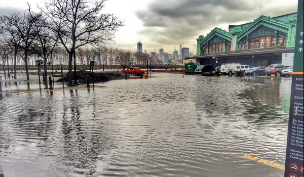
COLD & WET: Coastal Flooding and Winter Weather Advisories in Hoboken Through Wednesday, Feb. 10
(Photo by @juanmelli, via twitter)
After a wet morning at the train and ferry platforms, we’re keeping an eye on weather advisories in Hoboken…
The National Weather Service has issued a coastal Flood Advisory, which is in effect from 8 to midnight tonight and 7 am to noon EST Wednesday.
* Locations… coastal locations along the South Shore of Nassau… Queens and southwest Suffolk… New York Harbor… Newark Bay… the kills… and tidally affected portions of the Hackensack and Passaic rivers.
* Tidal departures… 1 1/2 to 2 1/2 ft above astronomical tides tonight. 1 to 2 ft above astronomical tides Wednesday morning.
* Timing… minor coastal flooding is expected with tonight’s high tide cycles… with minor to locally moderate for the South Shore back bays. Minor coastal flooding is expected with Wednesday morning high tide cycle.
* Coastal flood impacts… minor flooding of the most vulnerable shore roads and/or basements due to height of storm tide or wave splashover. Majority of roads remain passable with only isolated closures. There is no significant threat to life and any impact on property is minimal.
Winter Weather Advisory remains in effect until noon EST Wednesday…
* locations… New York City… adjacent portions of northeast New Jersey… and Long Island.
* Hazard types… snow.
* Accumulations… snow accumulation of 2 to 4 inches. Snow amounts will depend on where banding sets up. Some areas may get as low as an inch of snow. Some areas… especially across Long Island… could get snow accumulations of 3 to 5 inches.
* Temperatures… in the lower 30s.
* Visibilities… as low as one half mile at times.
Precautionary/preparedness actions…
A Winter Weather Advisory for snow means that periods of snow will cause travel difficulties. Be prepared for slippery roads and limited visibilities… and use caution while driving.

 Previous Article
 Next Article
 Earthquakes Rock Central Italy
  BEER BARRELS: Smokin’ Barrel Closes, Craft Beer Haven Set to Open in Fall
  Jersey City Offers COVID-19 Testing to ALL Residents; Antibody Tests Coming Soon
  As COVID-19 Cases Rise Throughout Hudson County, Residents & Health Professionals Vow to Respond
  Hoboken to Swear-In Six New Police Officers
  St. Peter’s Prep Lacrosse Camp — REGISTER NOW
  Three A’s Bar & Grill Changes Hands
  BELOVED: St. Francis Hoboken Prepares to Celebrate the Lives of Father Mike Guglielmelli, Dolores Guglielmelli and Antoinette Gallina — Lost in a Tragic Car Accident