
HOBO’CANE 2015 — Should We Start Freaking Out About Joaquin?
Here’s the latest, as of 7:45 a.m. on Thursday, October 1.
Various models have various scenarios for the storm’s path. All of those scenarios show Hoboken feeling an impact from this storm, either direct or indirect.
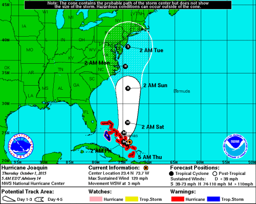
National Weather Service — October 1st at 7:45 a.m.
Recent history has proven that Hoboken can flood in the event of heavy rains.
If you were around for Sandy, you’ll recall that it really wasn’t all that enjoyable. So plan accordingly. This time of year, it’s a good idea to be prepared for anything.
That doesn’t necessarily mean you run to the store and decimate the bread and milk aisles. But you should have:
-Flashlights
-Batteries
-Candles
-Water (enough for 3 days—1 gallon per, day per person)
-Food (enough for 3 days)
-Medicine (prescriptions, pain reliever)
-Cash (your plastic won’t work in the event of power outages)
There are also steps we should take here in Hoboken to make this storm easier to endure.
From the City of Hoboken:
Residents Urged to Review Emergency Plans and Be Prepared
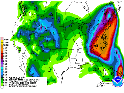
The City of Hoboken Office of Emergency Management is monitoring forecasts and making preparations for two major weather systems likely to impact our area. The threat of major coastal flooding, very heavy rainfall, and inland flooding has increased for Friday and Saturday, associated with the current storm system in advance of Hurricane Joaquin. Six to eight inches of additional rain are possible in the next week. The National Weather Service has issued a Coastal Flood Advisory from Thursday 6am to Friday 6am and a Coastal Flood Watch from Friday 6am to 6pm. Hurricane Joaquin may impact the region on Sunday and into early next week and could lead to major to record flooding depending on its trajectory and strength. Prior to the possible impacts from Hurricane Joaquin, several days of heavy rain will saturate the ground and high tides caused by strong winds could make it difficult for the sewer system to naturally drain into the river.
“We are closely tracking weather forecasts, talking to experts at Stevens, and planning for a serious one-two punch from back-to-back storm systems that could cause serious flooding from late Thursday into early next week,” said Mayor Dawn Zimmer. “Our Office of Emergency Management team is coordinating with all departments and agencies and making preparations to ensure the safety of our community. Most importantly, now is the time for residents to make sure that they have a plan in place and are prepared for all possibilities.”
The City has plans in place to activate an Emergency Operations Center and relocate flood-prone public safety operations if necessary. The City’s high water vehicle is ready to be deployed if needed, along with several small boats. The City will be moving municipal vehicles to higher ground along Washington Street between Observer Highway and 2nd Street as well as 13th Street to 14th Street. In addition, the City is pre-positioning backup generators, filling a potable water tank, and coordinating plans to open a shelter and distribution center if necessary.
Barricades have been pre-positioned to close off streets and “No Parking” signs have been posted in the most flood-prone areas to inform drivers of the possibility of flooding. For their own safety and to protect property, drivers must obey barricades and not drive through flooded roads. The wake generated by vehicles can cause additional flood damage to homes and businesses. Flood waters contain a mixture of rainwater and sewage, could be electrified due to fallen wires, and may conceal manhole covers that have become dislodged, so pedestrians should not walk through flooded areas.
North Hudson Sewerage Authority has been clearing out catch basins, and while a flood pump is operational, very heavy rain can still result in flooding.
Residents and businesses are urged to take the following steps to prepare:
- Sign up for the City’s Reverse 911 system at hobokennj.org/emergency and for email and text alerts through the Nixle system at www.hobokennj.org/alerts.
- Download weather apps, monitor weather forecasts, and sign up for weather alerts.
- Move parked vehicles from low-lying flood-prone areas to higher ground. A map of the most flood-prone areas is available at hobokennj.org/flooding, however flooding is possible beyond these areas.
- Bring in unsecured objects from patios and balconies and secure outdoor objects such as lawn furniture or garbage cans that could blow away and cause damage or injury.
- Create a family emergency communication plan. Visit ready.gov/prepare and download “Be Smart. Take Part: Create Your Family Emergency Communication Plan.”
- Create an emergency kit. Some of the items in a basic emergency kit include: one gallon of water per person per day for drinking and sanitation; at least a three-day supply of non-perishable food; battery-powered radio and a NOAA Weather Radio; flashlight and extra batteries; and First Aid kit.
- Make a pet emergency kit and plan. Visit ready.gov/caring-animals for more information.
- Refill prescriptions, make a list of prescriptions, and check on neighbors, especially the elderly and disabled, to make sure they are prepared.
Additional readiness tips are available at www.ready.gov. For updates, visit www.hobokennj.org or sign up for email or text alerts at www.hobokennj.org/alerts.
 Previous Article
 Next Article
 Fridays Are For Frank: “Jingle Bells”
  Bon Appétit: Choc O Pain Represents Le French Week in Hoboken
  SNEAKER ATTACK: Hoboken Police Seek Four Suspects in Theft of Wallet, Shoes
  hOMES: Weekly Insight Into Hoboken and Downtown Jersey City Real Estate Trends | MAY 11, 2017
  hOMES: Your Weekly Insight Into Hoboken Real Estate Trends | OCTOBER 21-27, 2016
  Putting Hoboken on the Map—Should NYC Have to Publicly Acknowledge the Existence of NJ?
  RESCUED: Stolen Liberty Humane Society Animal Control Van Recovered
  Work it Out Wednesday: Running in Hoboken